Dallas train map
You can find on this page the Dallas trains map to print and to download in PDF. The Dallas trains map presents the rail network and railway stations of the trains of Dallas in Texas - USA.
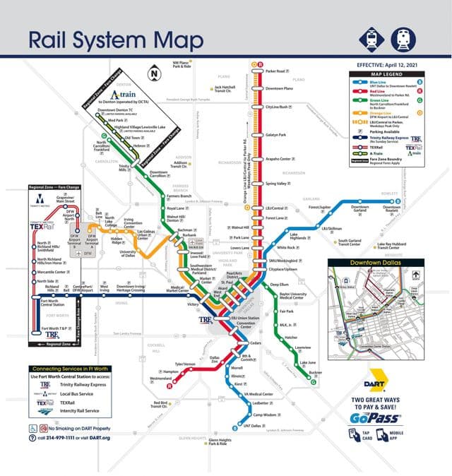
Dallas rail map
The Dallas rails map shows all the railway stations and lines of Dallas trains. This railway map of Dallas will allow you to easily plan your route with the trains of Dallas in Texas - USA. The Dallas rails map is downloadable in PDF, printable and free.
DART Red Line runs along North Central Expressway from Parker Road in Plano traveling south to downtown Dallas, then to Westmoreland in West Oak Cliff. The Blue Line travels south from Rowlett and Garland to downtown Dallas, then to UNT Dallas in South Oak Cliff as you can see in Dallas rail map. The Green Line provides service between North Carrollton/Frankford to Buckner in South Dallas. The Orange Line provides service between Parker Road and DFW Airport Station during peak hours weekdays and between LBJ/Central and DFW Airport Station all other times. All four lines serve Pearl/Arts District, St. Paul, Akard and West End stations in downtown Dallas. Hours of operation are approximately 5 a.m. to midnight. Check the destination sign on the train. If the doors do not open automatically, push the button on the side of the train. You may sit anywhere you like. Generally, areas near the front door and in the low-floor center car section are reserved for elderly and mobility-impaired passengers. You may carry on baby strollers, carts and other small items; just be sure they do not block the aisle.